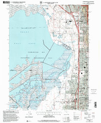
1998 Map of Farmington
USGS Topo · Published 2001About this map
Farmington and Bountiful anchor this landscape where the eastern shores of the Great Salt Lake meet the rising slopes of the Wasatch National Forest. The map illustrates a dense corridor of development squeezed between the saline marshes of the Farmington Bay Waterfowl Management Area and the mountains. This late-century update captures the suburban expansion of Centerville and West Bountiful, showing an intricate network of schools like Viewmont High Sch and civic centers such as the Davis Justice Center.
Find a feature on this map
63 named features on this map. Tap any name to fly to it.
Don’t see what you’re looking for? This feature index may not catch every label — zoom into the map to look around manually.
Map Details
Editions of this 1998 Farmington Map
This is the sole edition of this map. No revisions or reprints were ever made.
Other maps of this area

1885 · Salt Lake
USGS Topo · 1:250,000

1885 · Tooele Valley
USGS Topo · 1:250,000

1925 · Ft. Douglas
USGS Topo · 1:125,000

1928 · Ft. Douglas
USGS Topo · 1:125,000

1950 · Fort Douglas
USGS Topo · 1:24,000

1951 · Fort Douglas
USGS Topo · 1:24,000

1951 · Saltair
USGS Topo · 1:24,000

1951 · Salt Lake City North
USGS Topo · 1:24,000

1952 · Saltair NE
USGS Topo · 1:24,000

1952 · Farmington
USGS Topo · 1:24,000