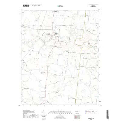
2019 Map of Farmington
USGS Topo · Published 2019About this map
Duck River winds through the heart of Marshall County, defining a landscape of agricultural valley bottoms and wooded heights like Powell Bluff. This 2019 survey captures a rural Tennessee environment where small hubs like Chapel Hill and Farmington anchor a network of country roads and family-named homesteads. The map is particularly dense with genealogical data, documenting dozens of family burial grounds such as Swanson Cem, Elliott Cem, and Osteen Cem, which are scattered among larger landmarks like the Clay Hill United Methodist Church Cem. Along the river near Wilhoite Mills, a developed system of trails—including the Adeline Wilhoite River Trail Loop and Hickory Ridge Loop—shows the modern preservation of this riverine corridor. The transition from the historic mill sites to infrastructure like Rocky Acres Airport illustrates the area's gradual evolution while maintaining its rural character.
Find a feature on this map
140 named features on this map. Tap any name to fly to it.
Don’t see what you’re looking for? This feature index may not catch every label — zoom into the map to look around manually.
Map Details
Editions of this 2019 Farmington Map
This is the sole edition of this map. No revisions or reprints were ever made.
Other maps of this area

1936 · Chapel Hill
USGS Topo · 1:24,000

1936 · Farmington
USGS Topo · 1:24,000

1936 · Rover
USGS Topo · 1:24,000

1936 · Belfast
USGS Topo · 1:24,000

1936 · Lewisburg
USGS Topo · 1:24,000

1936 · Verona
USGS Topo · 1:24,000

1936 · Rally Hill
USGS Topo · 1:24,000

1936 · Unionville
USGS Topo · 1:24,000

1936 · Bedford
USGS Topo · 1:24,000

1944 · Shelbyville
USGS Topo · 1:100,000