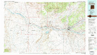
1980 Map of Farmington
USGS Topo · Published 1981About this map
The San Juan River corridor anchors this 1980 survey of the Four Corners region, where industrial development and ancestral lands meet. The map documents the significant energy infrastructure of the late 20th century, notably the Navajo Mine, San Juan Coal Mine, and Jewett Valley Coal Mine, which flank the river west of Farmington. This industrial footprint is situated within the Navajo Indian Reservation, while the northern reaches of the sheet extend into the Ute Mountain Indian Reservation across the Colorado-New Mexico state line.
Find a feature on this map
43 named features on this map. Tap any name to fly to it.
Don’t see what you’re looking for? This feature index may not catch every label — zoom into the map to look around manually.
Map Details
Editions of this 1980 Farmington Map
2 editions found
Other maps of this area

1886 · Abajo
USGS Topo · 1:250,000

1889 · Largo
USGS Topo · 1:250,000

1889 · Chaco
USGS Topo · 1:250,000

1892 · Abajo
USGS Topo · 1:250,000

1892 · Chaco
USGS Topo · 1:250,000

1892 · Canyon De Chelly
USGS Topo · 1:250,000

1893 · Abajo
USGS Topo · 1:250,000

1895 · Largo
USGS Topo · 1:250,000

1908 · Ignacio
USGS Topo · 1:125,000

1912 · Soda Canyon
USGS Topo · 1:62,500