2023 Map of Farnham
USGS Topo · Published 2023About this map
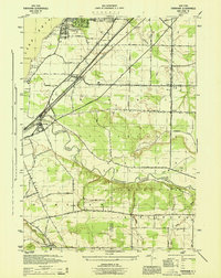
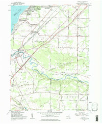
Farnham and the village of Brant anchor this survey of Erie County’s southwestern shoreline, where the landscape meets the waters of Lake Erie. The terrain is defined by the deep meandering path of Cattaraugus Creek, which forms a natural boundary between Erie, Chautauqua, and Cattaraugus Counties. Local genealogical interest is high here, with several significant burial sites documented including Holy Cross Lutheran Cem, Brant Cem, and Rathburn Cem. Along the lake, seasonal and residential developments like Angola Lake Shore Addition and Lake Erie Beach sit near prominent coastal features such as Farnham Point and Sunset Bay. The map also captures the inland agricultural character and small-town structure of Irving and Smith Mills, documenting the local road network and watercourses like Muddy Creek and Delaware Creek that drain toward the Great Lake.
Find a feature on this map
95 named features on this map. Tap any name to fly to it.
Don’t see what you’re looking for? This feature index may not catch every label — zoom into the map to look around manually.
Map Details
Editions of this 2023 Farnham Map
This is the sole edition of this map. No revisions or reprints were ever made.