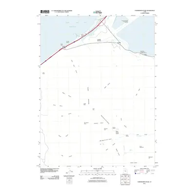
2011 Map of Farnsworth Peak
USGS Topo · Published 2011About this map
Great Salt Lake dominates the northern reaches of this map, where the shoreline is defined by infrastructure and recreation. Industrial operations are prominent near the lake, evidenced by the Kennecott Tailings Pond Number One Dam and Kennecott Tailings Pond Number Two Dam near the settlements of Garfield and Arthur. The southern terrain rises sharply into the Oquirrh Mountains, marked by significant summits like Farnsworth Peak and Kesler Peak. This landscape is heavily dissected by numerous canyons, including the Left Hand Fork Coon Canyon and Right Hand Fork Coon Canyon. Between the mountains and the shore, historical landmarks such as Black Rock and the Silver Sands Beach viewpoint offer a glimpse into the early 21st-century character of this transition zone between industrial development and the lake's edge.
Find a feature on this map
43 named features on this map. Tap any name to fly to it.
Don’t see what you’re looking for? This feature index may not catch every label — zoom into the map to look around manually.
Map Details
Editions of this 2011 Farnsworth Peak Map
This is the sole edition of this map. No revisions or reprints were ever made.
Other maps of this area

1885 · Tooele Valley
USGS Topo · 1:250,000

1951 · Saltair
USGS Topo · 1:24,000

1952 · Magna
USGS Topo · 1:24,000

1952 · Bingham Canyon
USGS Topo · 1:24,000

1952 · Antelope Island South
USGS Topo · 1:24,000
1952 · Lark
USGS Topo · 1:24,000

1952 · Garfield
USGS Topo · 1:24,000

1953 · Tooele
USGS Topo · 1:250,000

1955 · Mills Junction
USGS Topo · 1:24,000

1955 · Tooele
USGS Topo · 1:250,000