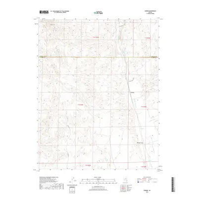
2018 Map of Farrier
USGS Topo · Published 2018About this map
Meadow Valley Wash defines the eastern corridor of this desert landscape, serving as the primary drainage through a region marked by ephemeral watercourses and vital springs. The settlement of Moapa Town and the rail-aligned point of Farrier anchor the southern and central portions of the sheet, where the Union Pacific corridor follows the natural topography of the wash. This 2018 survey illustrates the critical role of water in the arid environment, documenting numerous named sources including Lower Cone Springs, Cane Springs, and Grapevine Springs. To the north, the elevation rises toward the Bunker Hills, while the drainage network becomes increasingly complex with features like Farrier Wash, Whitmore Wash, and Mountain Valley Wash carving through the terrain. The map also delineates the jurisdictional boundary between Lincoln Co and Clark Co, showing how modern administrative lines intersect with historic township and range divisions.
Find a feature on this map
19 named features on this map. Tap any name to fly to it.
Don’t see what you’re looking for? This feature index may not catch every label — zoom into the map to look around manually.
Map Details
Editions of this 2018 Farrier Map
This is the sole edition of this map. No revisions or reprints were ever made.
Other maps of this area

1886 · Saint Thomas
USGS Topo · 1:250,000

1893 · Saint Thomas
USGS Topo · 1:250,000

1954 · Las Vegas
USGS Topo · 1:250,000

1957 · Las Vegas
USGS Topo · 1:250,000

1958 · Arrow Canyon
USGS Topo · 1:62,500

1958 · Moapa
USGS Topo · 1:62,500

1959 · Las Vegas
USGS Topo · 1:250,000

1962 · Las Vegas
USGS Topo · 1:250,000

1969 · Farrier
USGS Topo · 1:24,000
1969 · Wildcat Wash NE
USGS Topo · 1:24,000