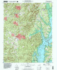
1993 Map of Farrington
USGS Topo · Published 1999About this map
B. Everett Jordan Lake dominates the eastern landscape of this Chatham County region, where the reservoir's fingers reach into the valleys once carved by Morgan Creek and Bush Creek. The map reflects a landscape in transition during the early 1990s, where the expansion of Farrington Village and proximity to the Orange County line signal suburban growth amidst older rural fixtures. Local heritage is deeply rooted in the numerous congregations and family burial grounds scattered throughout the hills, including Forest Grove Chapel, Mt Zion Church, and the Manns Chapel Cemetery. West of the lake, the high ground of Bennett Mountain and the dense Big Woods provide a stark contrast to the developed corridors. This survey provides a precise look at the road networks and water levels just before the turn of the twenty-first century.
Find a feature on this map
26 named features on this map. Tap any name to fly to it.
Don’t see what you’re looking for? This feature index may not catch every label — zoom into the map to look around manually.
Map Details
Editions of this 1993 Farrington Map
This is the sole edition of this map. No revisions or reprints were ever made.
Other maps of this area

1943 · Durham South
USGS Topo · 1:62,500

1946 · Chapel Hill
USGS Topo · 1:24,000

1947 · Chapel Hill
USGS Topo · 1:31,680

1951 · Farrington
USGS Topo · 1:24,000

1951 · Durham South
USGS Topo · 1:62,500

1953 · Raleigh
USGS Topo · 1:250,000

1954 · Raleigh
USGS Topo · 1:250,000

1968 · White Cross
USGS Topo · 1:24,000

1968 · Bynum
USGS Topo · 1:24,000

1969 · New Hope Dam
USGS Topo · 1:24,000