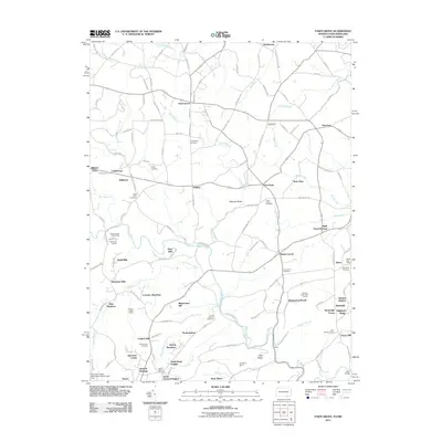
2011 Map of Fawn Grove
USGS Topo · Published 2011About this map
Fawn Grove serves as the focal point for this borderland study, where the rolling hills of York County meet the Maryland state line. The landscape is defined by the winding course of Deer Creek and its many tributaries, including Little Deer Creek and Falling Branch. This 2011 survey documents a transition from traditional agricultural settlements like Harkins and Constitution to modern residential enclaves such as Whispering Woods and Coventry Meadows. Genealogists will find a high density of burial sites across the landscape, from Heaps Cemetery near the border to the Holy Cross Cemetery further south. The area's character is shaped by landmarks like Kilgores Rocks and the Street Post Office, while the inclusion of the Little Deer Creek Watershed Site Number 1 Dam highlights modern land management alongside established dairy farms and nurseries like Grier Nursery Farms.
Find a feature on this map
152 named features on this map. Tap any name to fly to it.
Don’t see what you’re looking for? This feature index may not catch every label — zoom into the map to look around manually.
Map Details
Editions of this 2011 Fawn Grove Map
This is the sole edition of this map. No revisions or reprints were ever made.
Other maps of this area

1900 · Parkton
USGS Topo · 1:62,500

1901 · Belair
USGS Topo · 1:62,500

1902 · Parkton
USGS Topo · 1:62,500

1908 · York
USGS Topo · 1:62,500

1910 · York
USGS Topo · 1:62,500

1912 · Mc Calls Ferry
USGS Topo · 1:62,500

1942 · Bel Air
USGS Topo · 1:62,500

1943 · Mc Calls Ferry
USGS Topo · 1:62,500

1944 · Norrisville
USGS Topo · 1:31,680
1944 · Phoenix
USGS Topo · 1:31,680