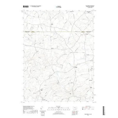
2019 Map of Fawn Grove
USGS Topo · Published 2019About this map
The Mason-Dixon Rd provides the geographic spine for this survey of the Pennsylvania-Maryland borderlands, where the rural landscapes of York and Harford counties meet. This agricultural and wooded region is defined by the winding course of Deer Creek, which gathers tributaries like Little Deer Cr and Falling Br as it flows south toward Jarrettsville. The map documents a cluster of small crossroad settlements and hamlets, including Fawn Grove, Harkins, and Pylesville, each anchored by generational landmarks.
Find a feature on this map
130 named features on this map. Tap any name to fly to it.
Don’t see what you’re looking for? This feature index may not catch every label — zoom into the map to look around manually.
Map Details
Editions of this 2019 Fawn Grove Map
This is the sole edition of this map. No revisions or reprints were ever made.
Other maps of this area

1900 · Parkton
USGS Topo · 1:62,500

1901 · Belair
USGS Topo · 1:62,500

1902 · Parkton
USGS Topo · 1:62,500

1908 · York
USGS Topo · 1:62,500

1910 · York
USGS Topo · 1:62,500

1912 · Mc Calls Ferry
USGS Topo · 1:62,500

1942 · Bel Air
USGS Topo · 1:62,500

1943 · Mc Calls Ferry
USGS Topo · 1:62,500

1944 · Norrisville
USGS Topo · 1:31,680
1944 · Phoenix
USGS Topo · 1:31,680