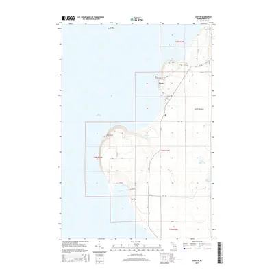
2014 Map of Fayette
USGS Topo · Published 2014About this map
The Garden Peninsula shoreline along Lake Michigan dominates this survey, characterized by the dramatic vertical elevations of Middle Bluff and Burnt Bluff. The settlement of Fayette is a central focal point, surrounded by historic sites including the Saint Josephs Catholic Church and its associated Saint Josephs Catholic Church Cem, as well as the nearby Saint Peters Cem. Further south, the community at Sac Bay sits tucked along the coast, where the Sac Bay Cem and several local road junctions like 8th RD and GG.25 RD mark the terrestrial footprint. The map captures a landscape defined by its coastal geography, from the treacherous Big Bay De Noc Shoal to the quiet waters of Little Lake and Little Sucker Lake.
Find a feature on this map
39 named features on this map. Tap any name to fly to it.
Don’t see what you’re looking for? This feature index may not catch every label — zoom into the map to look around manually.
Map Details
Editions of this 2014 Fayette Map
This is the sole edition of this map. No revisions or reprints were ever made.
Other maps of this area

1932 · Burnt Bluff SW
USGS Topo · 1:31,680

1932 · Burnt Bluff NE
USGS Topo · 1:31,680

1932 · Burnt Bluff NW
USGS Topo · 1:31,680

1932 · Garden SE
USGS Topo · 1:31,680

1932 · Rapid River SE
USGS Topo · 1:31,680

1954 · Escanaba
USGS Topo · 1:250,000

1957 · Escanaba
USGS Topo · 1:250,000

1958 · Escanaba
USGS Topo · 1:250,000

1958 · Garden
USGS Topo · 1:62,500

1958 · Peninsula Point
USGS Topo · 1:62,500