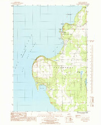
1985 Map of Fayette
USGS Topo · Published 1985About this map
The Garden Peninsula shoreline along Big Bay De Noc is defined by dramatic coastal formations like Middle Bluff and Burnt Bluff. This mid-1980s survey documents the cultural and natural landscape of the Fayette State Park area, specifically highlighting the Fayette (Site) near Snail Shell Harbor. The map records significant local genealogy markers, including Hinks Cem and St Peters Cem, alongside community landmarks such as the Townhall and St Peter the Fisherman Ch. The transition from the developed park areas to the wilder reaches of the Lake Superior State Forest illustrates the dual nature of this Lake Michigan frontage. Settlement patterns are concentrated around the sheltered waters of Sac Bay and the historic industrial site at Fayette, while the interior remains a mosaic of wetlands like Mud Lake and Little Sucker Lake.
Find a feature on this map
33 named features on this map. Tap any name to fly to it.
Don’t see what you’re looking for? This feature index may not catch every label — zoom into the map to look around manually.
Map Details
Editions of this 1985 Fayette Map
This is the sole edition of this map. No revisions or reprints were ever made.
Other maps of this area

1932 · Burnt Bluff SW
USGS Topo · 1:31,680

1932 · Burnt Bluff NE
USGS Topo · 1:31,680

1932 · Burnt Bluff NW
USGS Topo · 1:31,680

1932 · Garden SE
USGS Topo · 1:31,680

1932 · Rapid River SE
USGS Topo · 1:31,680

1954 · Escanaba
USGS Topo · 1:250,000

1957 · Escanaba
USGS Topo · 1:250,000

1958 · Escanaba
USGS Topo · 1:250,000

1958 · Garden
USGS Topo · 1:62,500

1958 · Peninsula Point
USGS Topo · 1:62,500