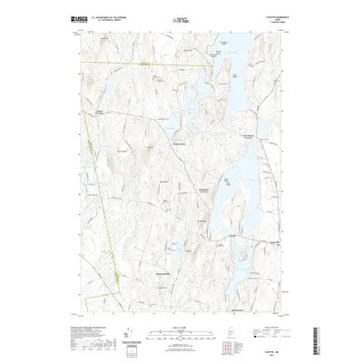
2021 Map of Fayette
USGS Topo · Published 2021About this map
Fayette and its surrounding hamlets are defined by a complex network of glacial ponds and narrow ridges where Kennebec, Franklin, and Androscoggin counties meet. The landscape is dotted with small historical settlements such as North Fayette, Sanderson Corners, and Richmond Mill, reflecting the early industrial and agricultural patterns of central Maine. Significant local history is preserved in numerous family and community burial grounds, including the Old North Fayette Cem and Fayette Mills Cem, which sit near the many waterways that once powered local industry. The terrain rises to prominent points like Fayette Ridge and Mt Winnebago, overlooking large bodies of water such as Echo Lake and Parker Pond. To the east, the village of Kents Hill marks a point of higher elevation, while the southern reaches of the map transition toward North Wayne, illustrating the dense distribution of 19th-century crossroads communities that persist into the modern era.
Find a feature on this map
128 named features on this map. Tap any name to fly to it.
Don’t see what you’re looking for? This feature index may not catch every label — zoom into the map to look around manually.
Map Details
Editions of this 2021 Fayette Map
This is the sole edition of this map. No revisions or reprints were ever made.
Other maps of this area

1892 · Augusta
USGS Topo · 1:62,500

1894 · Norridgewock
USGS Topo · 1:62,500

1898 · Norridgewock
USGS Topo · 1:62,500

1910 · Livermore
USGS Topo · 1:62,500

1912 · Livermore
USGS Topo · 1:62,500

1924 · Farmington
USGS Topo · 1:62,500

1941 · Livermore
USGS Topo · 1:62,500

1941 · Augusta
USGS Topo · 1:62,500

1943 · Augusta
USGS Topo · 1:62,500

1943 · Norridgewock
USGS Topo · 1:62,500