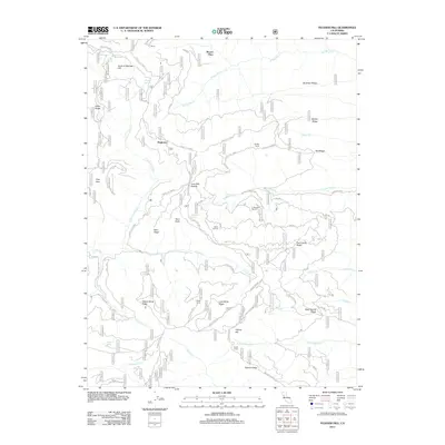
2012 Map of Felkner Hill
USGS Topo · Published 2012About this map
Dogtown and Meyers Place anchor the north-central portion of this mountain landscape, which is defined by an intricate network of ridges and watercourses. The drainage patterns of N Fork Elk Cr and Corbin Cr shape the terrain, creating deep divides such as Ivory Mill Saddle and the prominent Kern Ridge. The area is dotted with small-scale agricultural and seasonal settlements, including Dixon Orchard, Smiley Camp, and El Manzano Rancho, suggesting a history of specialized land use within the national forest system.
Find a feature on this map
60 named features on this map. Tap any name to fly to it.
Don’t see what you’re looking for? This feature index may not catch every label — zoom into the map to look around manually.
Map Details
Editions of this 2012 Felkner Hill Map
This is the sole edition of this map. No revisions or reprints were ever made.
Other maps of this area

1919 · Elk Creek
USGS Topo · 1:62,500

1922 · Hullville
USGS Topo · 1:62,500

1948 · Elk Creek
USGS Topo · 1:62,500

1951 · Lake Pillsbury
USGS Topo · 1:62,500

1951 · Stonyford
USGS Topo · 1:62,500

1952 · Hull Mountain
USGS Topo · 1:62,500

1957 · Elk Creek
USGS Topo · 1:62,500

1957 · Ukiah
USGS Topo · 1:250,000

1960 · Ukiah
USGS Topo · 1:250,000
1967 · Plaskett meadows
USGS Topo · 1:24,000