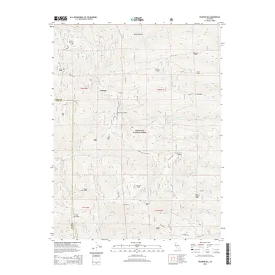
2015 Map of Felkner Hill
USGS Topo · Published 2015About this map
Meyers Place and the historical site of Dogtown highlight the early settlement patterns within this corner of the Mendocino National Forest. Located along the boundary of Glenn and Lake counties, the landscape is defined by a complex network of high ridges and reliable water sources. Vital watering points like Jumbo Spring, Summit Springs, and Jerusalem Spring supported the travel and livestock operations in these highlands. The map shows the intersection of several notable geographic features, including Felkner Hill and Ivory Mill Saddle, which provided natural passes and vantage points. The presence of named locations such as Happy Camp Ridge and Lost Camp Ridge suggests a history of seasonal usage by early travelers and forest workers navigating the rugged terrain between the watersheds of N Fork Elk Cr and Briscoe Cr.
Find a feature on this map
52 named features on this map. Tap any name to fly to it.
Don’t see what you’re looking for? This feature index may not catch every label — zoom into the map to look around manually.
Map Details
Editions of this 2015 Felkner Hill Map
This is the sole edition of this map. No revisions or reprints were ever made.
Other maps of this area

1919 · Elk Creek
USGS Topo · 1:62,500

1922 · Hullville
USGS Topo · 1:62,500

1948 · Elk Creek
USGS Topo · 1:62,500

1951 · Lake Pillsbury
USGS Topo · 1:62,500

1951 · Stonyford
USGS Topo · 1:62,500

1952 · Hull Mountain
USGS Topo · 1:62,500

1957 · Elk Creek
USGS Topo · 1:62,500

1957 · Ukiah
USGS Topo · 1:250,000

1960 · Ukiah
USGS Topo · 1:250,000
1967 · Plaskett meadows
USGS Topo · 1:24,000