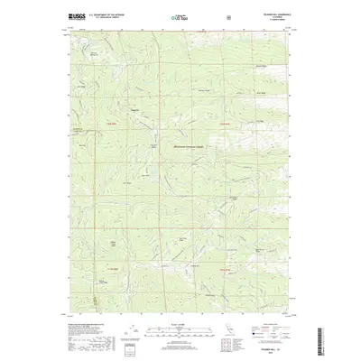
2018 Map of Felkner Hill
USGS Topo · Published 2018About this map
Mendocino National Forest defines the rugged divide between Glenn and Lake Counties in this 2018 survey. The landscape is marked by a complex network of named ridges and canyons, including the prominent Felkner Hill and Bowman Ridge. The presence of Ivory Mill Saddle and the associated Ivory Mill Rd suggests a legacy of timber history in this remote section of Northern California. Water resources are primarily found in high-elevation seeps like Jumbo Spring and Hayward Spring, which feed the many creeks cutting through the terrain, such as Clover Cr and Dutch Oven Cr.
Find a feature on this map
59 named features on this map. Tap any name to fly to it.
Don’t see what you’re looking for? This feature index may not catch every label — zoom into the map to look around manually.
Map Details
Editions of this 2018 Felkner Hill Map
This is the sole edition of this map. No revisions or reprints were ever made.
Other maps of this area

1919 · Elk Creek
USGS Topo · 1:62,500

1922 · Hullville
USGS Topo · 1:62,500

1948 · Elk Creek
USGS Topo · 1:62,500

1951 · Lake Pillsbury
USGS Topo · 1:62,500

1951 · Stonyford
USGS Topo · 1:62,500

1952 · Hull Mountain
USGS Topo · 1:62,500

1957 · Elk Creek
USGS Topo · 1:62,500

1957 · Ukiah
USGS Topo · 1:250,000

1960 · Ukiah
USGS Topo · 1:250,000
1967 · Plaskett meadows
USGS Topo · 1:24,000