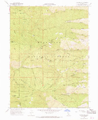
1968 Map of Felkner Hill
USGS Topo · Published 1969About this map
The Mendocino National Forest defines this high-elevation landscape, where the rugged terrain of Glenn and Lake counties meets. The 1960s economy of the area is reflected in the timber and agricultural infrastructure, notably the Ivory Mill and nearby Ivory Mill Station and Ivory Mill Saddle. Local cultivation is represented by the Dixon Orchard, while several remote outposts such as Meyers Place, Dogtown, and El Manzano Rancho suggest a history of seasonal ranching and habitation.
Find a feature on this map
53 named features on this map. Tap any name to fly to it.
Don’t see what you’re looking for? This feature index may not catch every label — zoom into the map to look around manually.
Map Details
Editions of this 1968 Felkner Hill Map
2 editions found
Other maps of this area

1919 · Elk Creek
USGS Topo · 1:62,500

1922 · Hullville
USGS Topo · 1:62,500

1948 · Elk Creek
USGS Topo · 1:62,500

1951 · Lake Pillsbury
USGS Topo · 1:62,500

1951 · Stonyford
USGS Topo · 1:62,500

1952 · Hull Mountain
USGS Topo · 1:62,500

1957 · Elk Creek
USGS Topo · 1:62,500

1957 · Ukiah
USGS Topo · 1:250,000

1960 · Ukiah
USGS Topo · 1:250,000
1967 · Plaskett meadows
USGS Topo · 1:24,000