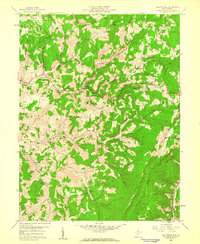
1958 Map of Fellowsville
USGS Topo · Published 1960About this map
The George Washington Highway serves as the primary east-west artery through this corner of Preston County, connecting the valley settlements of Fellowsville and Evansville. The landscape is defined by the steep ridges of Laurel Mountain and a network of stream-fed hollows, including Little Sandy Creek and Buffalo Creek. This 1958 field-checked survey documents a rural community centered around small crossroads and family-named landmarks.
Find a feature on this map
29 named features on this map. Tap any name to fly to it.
Don’t see what you’re looking for? This feature index may not catch every label — zoom into the map to look around manually.
Map Details
Editions of this 1958 Fellowsville Map
3 editions found
Other maps of this area

1886 · St. George
USGS Topo · 1:125,000

1891 · St. George
USGS Topo · 1:125,000

1907 · Thornton
USGS Topo · 1:62,500

1907 · Kingwood
USGS Topo · 1:62,500

1907 · Belington
USGS Topo · 1:62,500

1908 · Parsons
USGS Topo · 1:62,500

1925 · Kingwood
USGS Topo · 1:62,500

1926 · Thornton
USGS Topo · 1:62,500

1926 · Parsons
USGS Topo · 1:62,500

1927 · Belington
USGS Topo · 1:62,500