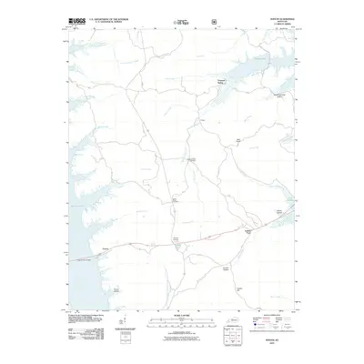
2010 Map of Fenton
USGS Topo · Published 2010About this map
Kentucky Lake and Lake Barkley frame the narrow peninsula of land between the lakes, a landscape defined by water and the legacy of mid-twentieth-century infrastructure. Small settlements like Fenton, Golden Pond, and Energy occupy this stretch of western Kentucky, connected by the Eggner Ferry Bridge spanning the western waters. The map reveals a high concentration of small family and community burial grounds, such as Pleasant Valley Cemetery, Jenny Ridge Cemetery, and Mathery Cemetery, which persist alongside newer recreational waters like Energy Lake. The terrain is characterized by numerous hollows and hills, including Boardinghouse Hollow and Gordon Hill, while numerous creeks like Crooked Creek and Barnett Creek drain into the primary reservoirs. This documentation from 2010 shows the area long after the flooding of the valleys, preserving the names of the ridges and springs like Ferguson Spring that remain above the waterline.
Find a feature on this map
36 named features on this map. Tap any name to fly to it.
Don’t see what you’re looking for? This feature index may not catch every label — zoom into the map to look around manually.
Map Details
Editions of this 2010 Fenton Map
This is the sole edition of this map. No revisions or reprints were ever made.
Other maps of this area

1936 · Mont
USGS Topo · 1:24,000

1936 · Fenton
USGS Topo · 1:24,000

1936 · Hiatt
USGS Topo · 1:24,000

1936 · Birmingham
USGS Topo · 1:24,000

1936 · Golden Pond
USGS Topo · 1:48,000

1936 · Rushing
USGS Topo · 1:24,000

1936 · Hico
USGS Topo · 1:24,000
1938 · Birmingham
USGS Topo · 1:24,000
1940 · Hiatt
USGS Topo · 1:24,000

1942 · Hico
USGS Topo · 1:24,000