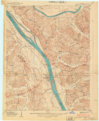
1938 Map of Birmingham
USGS Topo · Published 1938About this map
Birmingham sits at the heart of this Tennessee River landscape, a riverfront community defined by its proximity to the water before the creation of Kentucky Lake. This 1938 survey captures the intricate relationship between the river and the surrounding hills, where Hillman Ferry and Birmingham Ferry served as vital transportation links connecting Marshall and Lyon counties. The terrain is a network of ridges and basins, with the Tennessee River and Cumberland River running nearly parallel through the Narrows. The map reveals a deeply settled rural landscape, evidenced by numerous small community centers such as Star Lime Works PO and Boyds Landing. Local life is anchored by family-named landmarks and institutions, including Harvard Ch, Yale Sch, and the Whiteside Cem. The presence of the Bray Trail and various schools like Brandon Sch suggests a well-established network of upland homesteads tied to the river valley's economy.
Find a feature on this map
65 named features on this map. Tap any name to fly to it.
Don’t see what you’re looking for? This feature index may not catch every label — zoom into the map to look around manually.
Map Details
Editions of this 1938 Birmingham Map
This is the sole edition of this map. No revisions or reprints were ever made.
Other maps of this area

1928 · Eddyville
USGS Topo · 1:48,000

1929 · Smithland
USGS Topo · 1:62,500

1931 · Eddyville
USGS Topo · 1:62,500

1936 · Eddyville
USGS Topo · 1:48,000

1936 · Mont
USGS Topo · 1:24,000

1936 · Fenton
USGS Topo · 1:24,000

1936 · Grand Rivers
USGS Topo · 1:24,000

1936 · Hardin
USGS Topo · 1:24,000

1936 · Smithland
USGS Topo · 1:48,000

1936 · Hiatt
USGS Topo · 1:24,000