
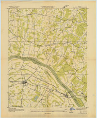
1936 Map of Grand Rivers
USGS Topo · Published 1936About this map
Grand Rivers serves as the focal point of this 1936 survey, situated near the crucial Divide between major waterway systems. The landscape is defined by the proximity of the Cumberland River, which winds along the boundary between Lyon and Livingston Counties. This particular era, documented by the Tennessee Valley Authority, captures the river environment as Ohio River Pool 52 (Elev 302 Ft), reflecting the managed water levels of the mid-1930s. The terrain transitions into the Tennessee Basin, illustrating the complex drainage patterns and narrow land strips between the great rivers of Western Kentucky. This map provides a clear record of the area's transportation and settlement layout before the massive landscape changes brought about by later regional hydroelectric and dam projects.
Find a feature on this map
6 named features on this map. Tap any name to fly to it.
Don’t see what you’re looking for? This feature index may not catch every label — zoom into the map to look around manually.
Map Details
Editions of this 1936 Grand Rivers Map
This is the sole edition of this map. No revisions or reprints were ever made.
Other maps of this area

1928 · Eddyville
USGS Topo · 1:48,000

1929 · Smithland
USGS Topo · 1:62,500

1931 · Eddyville
USGS Topo · 1:62,500

1936 · Eddyville
USGS Topo · 1:48,000

1936 · Mont
USGS Topo · 1:24,000

1936 · Smithland
USGS Topo · 1:48,000

1936 · Benton
USGS Topo · 1:48,000

1936 · Birmingham
USGS Topo · 1:24,000

1936 · Golden Pond
USGS Topo · 1:48,000
1936 · Calvert City
USGS Topo · 1:24,000