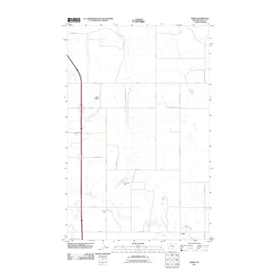
2011 Map of Ferdig
USGS Topo · Published 2011About this map
Ohio Camp, Texas Pacific Camp, and California Camp anchor this landscape in Toole County, reflecting the area's specialized industrial housing patterns north of Ferdig. The map captures the infrastructure of the Kevin-Sunburst Oil Fld, where a grid of local roads like Oilmont North Rd and Ferdig North Rd services the energy production sites. This 2011 survey highlights the intersection of resource extraction and local geography, most notably at The Pewter Dam, which provides a rare water feature in this high plains environment. The terrain is organized by a systematic road network, including Swayze N and Swayze E, showing how the land has been subdivided to support the oil field's operations and the small residential camps established for its workers.
Find a feature on this map
23 named features on this map. Tap any name to fly to it.
Don’t see what you’re looking for? This feature index may not catch every label — zoom into the map to look around manually.
Map Details
Editions of this 2011 Ferdig Map
This is the sole edition of this map. No revisions or reprints were ever made.
Other maps of this area

1939 · Sunburst
USGS Topo · 1:62,500

1943 · Antelope Coulee
USGS Topo · 1:62,500

1943 · Shelby
USGS Topo · 1:62,500

1945 · West Butte
USGS Topo · 1:62,500

1954 · Shelby
USGS Topo · 1:250,000

1958 · Shelby
USGS Topo · 1:250,000

1984 · Sweet Grass Hills
USGS Topo · 1:100,000
1986 · Ferdig
USGS Topo · 1:24,000
1986 · Sunburst
USGS Topo · 1:24,000
1986 · Antelope Coulee NW
USGS Topo · 1:24,000