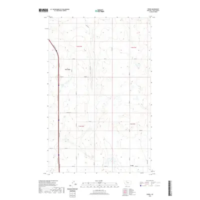
2020 Map of Ferdig
USGS Topo · Published 2020About this map
Ohio Camp and Ferdig anchor this section of Toole County, where the high plains are carved by a network of local service roads and land leases. The landscape is structured by the Public Land Survey System, as evidenced by the boundaries of t36n r2w and t36n r1w, reflecting a history of organized land management in northern Montana. Transportation routes such as Oilmont N, Coolidge Rd, and the Westside Frontage along the interstate corridor trace the movement of goods and people through this agricultural and industrial region. The presence of the Nutter Lease suggests the historical and ongoing importance of mineral or land rights in the area. This survey by the U.S. Geological Survey provides a clear look at the township and range divisions that have defined the rural character of this region for generations.
Find a feature on this map
25 named features on this map. Tap any name to fly to it.
Don’t see what you’re looking for? This feature index may not catch every label — zoom into the map to look around manually.
Map Details
Editions of this 2020 Ferdig Map
This is the sole edition of this map. No revisions or reprints were ever made.
Other maps of this area

1939 · Sunburst
USGS Topo · 1:62,500

1943 · Antelope Coulee
USGS Topo · 1:62,500

1943 · Shelby
USGS Topo · 1:62,500

1945 · West Butte
USGS Topo · 1:62,500

1954 · Shelby
USGS Topo · 1:250,000

1958 · Shelby
USGS Topo · 1:250,000

1984 · Sweet Grass Hills
USGS Topo · 1:100,000
1986 · Ferdig
USGS Topo · 1:24,000
1986 · Sunburst
USGS Topo · 1:24,000
1986 · Antelope Coulee NW
USGS Topo · 1:24,000