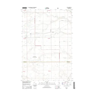
2014 Map of Fibre
USGS Topo · Published 2014About this map
The Hiawatha National Forest dominates this section of the Upper Peninsula, where the small settlements of Fibre and Dryburg sit along the east-west corridor of Trout Lake Rd. The landscape is defined by a dense network of waterways draining the timberlands, including the northward-flowing Pine River and several significant creeks like Biscuit Cr, Trout Brook, and Bear Cr. In the southern portion of the map, the terrain transitions across the Chippewa and Mackinac County line, characterized by the winding path of Chub Cr. Transportation in this rural area relies on a grid of forest and county roads, such as W Saaranen Rd and W Bear Creek Rd, while the Dowd Field Airport provides a small aviation waypoint amidst the woods and wetlands.
Find a feature on this map
29 named features on this map. Tap any name to fly to it.
Don’t see what you’re looking for? This feature index may not catch every label — zoom into the map to look around manually.
Map Details
Editions of this 2014 Fibre Map
This is the sole edition of this map. No revisions or reprints were ever made.
Other maps of this area

1931 · Ozark SE
USGS Topo · 1:31,680

1941 · Strongs
USGS Topo · 1:63,360

1941 · Brimley
USGS Topo · 1:63,360

1951 · Sullivan Creek
USGS Topo · 1:24,000

1951 · Raco
USGS Topo · 1:24,000

1951 · Kinross
USGS Topo · 1:24,000

1951 · Brimley
USGS Topo · 1:62,500

1951 · Strongs
USGS Topo · 1:62,500
1953 · Rudyard
USGS Topo · 1:24,000

1953 · Fibre
USGS Topo · 1:24,000