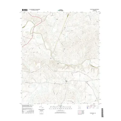
2017 Map of Fickling Mill
USGS Topo · Published 2017About this map
The Flint River carves a deep valley through the center of this landscape where Taylor, Upson, and Crawford counties converge. The namesake Fickling Mill sits near the confluence of Patsiliga Cr, illustrating the area's long-standing reliance on the river system for power and transport. This 2017 data reflects a rural topography defined by small settlements like Salem and a network of family-centered landmarks. Genealogists will find a high concentration of burial sites, including the Midway Cem, Wainwright Cem, and Crowell Cem, often located near crossroads such as W Old Wire Rd. Large river features like Harris Island and Reeves Shoals indicate the natural complexity of the waterway before it reaches the coastal plain.
Find a feature on this map
63 named features on this map. Tap any name to fly to it.
Don’t see what you’re looking for? This feature index may not catch every label — zoom into the map to look around manually.
Map Details
Editions of this 2017 Fickling Mill Map
This is the sole edition of this map. No revisions or reprints were ever made.
Other maps of this area

1935 · Thomaston
USGS Topo · 1:48,000

1939 · Thomaston
USGS Topo · 1:62,500

1951 · Yatesville
USGS Topo · 1:62,500

1955 · Phenix City
USGS Topo · 1:250,000

1957 · Phenix City
USGS Topo · 1:250,000

1958 · Phenix City
USGS Topo · 1:250,000

1971 · Prattsburg
USGS Topo · 1:24,000
1971 · Lincoln Park
USGS Topo · 1:24,000

1971 · Fickling Mill
USGS Topo · 1:24,000

1971 · Reynolds
USGS Topo · 1:24,000