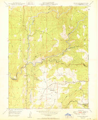
1950 Map of Fiddletown
USGS Topo · Published 1950About this map
The Shenandoah Valley of the Sierra Nevada foothills is defined by the complex drainage of the Cosumnes River and its multiple forks in this 1950 survey. The landscape transitions from the prominent Logtown Ridge in the west toward the settlement of Fiddletown in the southeast. This era of California's history is reflected in the hydraulic infrastructure scattered across the hills, including the Plymouth Ditch, various flumes, and tunnels that supported local industry and agriculture. Rural community life is anchored by the Shenandoah Sch and the nearby Shenandoah Cem. Resource extraction remains a visible part of the topography, evidenced by the Briarcliff Mines near the Middle Fork Cosumnes River. These details provide a look at the Amador and El Dorado county line before modern development altered the rural character of the region.
Find a feature on this map
31 named features on this map. Tap any name to fly to it.
Don’t see what you’re looking for? This feature index may not catch every label — zoom into the map to look around manually.
Map Details
Editions of this 1950 Fiddletown Map
This is the sole edition of this map. No revisions or reprints were ever made.
Other maps of this area

1889 · Jackson
USGS Topo · 1:125,000

1891 · Placerville
USGS Topo · 1:125,000

1892 · Jackson
USGS Topo · 1:125,000

1892 · Placerville
USGS Topo · 1:125,000

1893 · Placerville
USGS Topo · 1:125,000

1897 · Jackson
USGS Topo · 1:125,000

1902 · Jackson
USGS Topo · 1:125,000
1941 · Sutter Creek
USGS Topo · 1:62,500
1944 · Sutter Creek
USGS Topo · 1:62,500

1947 · Sacramento
USGS Topo · 1:250,000