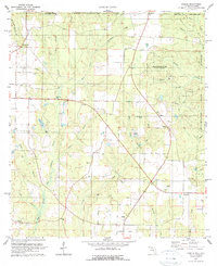
1978 Map of Fidelis
USGS Topo · Published 1978About this map
Fidelis and the surrounding pine-rich landscape of Santa Rosa County are defined by a network of rural settlements and extensive timberlands in the late 1970s. This region, situated along the Alabama-Florida border, is characterized by the convergence of the West Fork and East Fork of Big Coldwater Creek. The economy and land use are centered on the Blackwater River State Forest and the Escambia National Experimental Forest, with numerous claypits and oil wells scattered across the terrain. Local social life is anchored by a significant number of rural congregations, including Golden Memorial Ch, Fidelis Ch, and Cobbtown Ch. The map provides excellent genealogical detail through sites like Old Fidelis Cem and smaller settlements like Mt Carmel and Berrydale, illustrating the persistent agrarian and forestry-based community structure of the Florida Panhandle.
Find a feature on this map
48 named features on this map. Tap any name to fly to it.
Don’t see what you’re looking for? This feature index may not catch every label — zoom into the map to look around manually.
Map Details
Editions of this 1978 Fidelis Map
2 editions found
Other maps of this area

1943 · Jay
USGS Topo · 1:62,500

1948 · Munson
USGS Topo · 1:62,500

1950 · Munson
USGS Topo · 1:62,500

1953 · Andalusia
USGS Topo · 1:250,000

1957 · Andalusia
USGS Topo · 1:250,000

1957 · Pensacola
USGS Topo · 1:250,000

1959 · Pensacola
USGS Topo · 1:250,000

1959 · Brewton South
USGS Topo · 1:24,000

1960 · Pensacola
USGS Topo · 1:250,000

1960 · Brewton South
USGS Topo · 1:24,000