
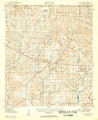
1950 Map of Munson
USGS Topo · Published 1950About this map
Munson serves as a central hub within the sprawling Blackwater River State Forest, appearing here at a time when the timber and turpentine economies of northern Florida and southern Alabama were deeply intertwined. The landscape is defined by an intricate network of waterways, including Big Coldwater Creek and Big Juniper Creek, which historically supported the region's logging operations. Settlement patterns follow these drainages and the historic Three Notch Road, with community life centered around local institutions like the Munson High Sch and rural congregations such as Valley Grove Ch and Beaver Creek Ch.
Find a feature on this map
81 named features on this map. Tap any name to fly to it.
Don’t see what you’re looking for? This feature index may not catch every label — zoom into the map to look around manually.
Map Details
Editions of this 1950 Munson Map
2 editions found
Other maps of this area

1920 · Milton
USGS Topo · 1:62,500

1934 · Holt
USGS Topo · 1:48,000

1934 · Harold
USGS Topo · 1:62,500

1937 · Holt
USGS Topo · 1:62,500

1937 · Harold
USGS Topo · 1:62,500

1938 · Harold
USGS Topo · 1:62,500

1941 · Milton
USGS Topo · 1:62,500

1943 · Milton
USGS Topo · 1:62,500

1943 · Jay
USGS Topo · 1:62,500

1948 · Munson
USGS Topo · 1:62,500