
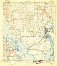
1943 Map of Milton
USGS Topo · Published 1943About this map
Milton and Bagdad anchor this 1940s landscape where the Escambia River and Blackwater River converge into the expansive Escambia Bay. This era shows a region defined by its water-dependent industry and transit, with the Louisville and Nashville RR crossing the bay and the Nashville and Tallahassee Base Line providing a critical surveying anchor. Small inland settlements like Wallace and Pace appear alongside rural community centers such as Union Valley Ch and the Robinson Sch. The coastal fringes are a maze of bayous and basins, including Noriegas Bayou, Coulter Basin, and Peters Bayou Basin, reflecting the complex hydrology of the Florida Panhandle before mid-century development. Notable local landmarks like the County Farm and Conners Still highlight the agricultural and extractive roots of Santa Rosa and Escambia counties.
Find a feature on this map
77 named features on this map. Tap any name to fly to it.
Don’t see what you’re looking for? This feature index may not catch every label — zoom into the map to look around manually.
Map Details
Editions of this 1943 Milton Map
2 editions found
Other maps of this area

1920 · Milton
USGS Topo · 1:62,500

1921 · Holley
USGS Topo · 1:62,500

1921 · Pensacola
USGS Topo · 1:62,500

1921 · Fort Barrancas
USGS Topo · 1:62,500

1921 · Muscogee
USGS Topo · 1:62,500

1934 · Harold
USGS Topo · 1:62,500

1936 · Holley
USGS Topo · 1:48,000

1937 · Harold
USGS Topo · 1:62,500

1938 · Holley
USGS Topo · 1:62,500

1938 · Harold
USGS Topo · 1:62,500