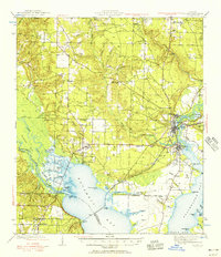
1941 Map of Milton
USGS Topo · Published 1956About this map
Milton and the neighboring industrial settlement of Bagdad serve as the focal points of this 1940s survey, where the timber and rail economy of the Florida Panhandle is clearly visible. The Louisville and Nashville railroad cuts across the landscape, connecting the interior with waterfront hubs along Escambia Bay and the Blackwater River. The intricate waterways of the Escambia River delta, including Brosnaham Island and numerous bayous like Woodbine Bayou and Saultsman Bayou, highlight a complex aquatic environment before modern coastal development. Local genealogy and community history are preserved through labels for the County Farm, the Union Valley Ch, and scattered family burial grounds such as Allen Cem and Strickland Cem. Smaller communities like Floridatown, Pace, and Wallace appear as they were just prior to the post-war expansion of the Pensacola region.
Find a feature on this map
74 named features on this map. Tap any name to fly to it.
Don’t see what you’re looking for? This feature index may not catch every label — zoom into the map to look around manually.
Map Details
Editions of this 1941 Milton Map
2 editions found

Other maps of this area

1920 · Milton
USGS Topo · 1:62,500

1921 · Holley
USGS Topo · 1:62,500

1921 · Pensacola
USGS Topo · 1:62,500

1921 · Fort Barrancas
USGS Topo · 1:62,500

1921 · Muscogee
USGS Topo · 1:62,500

1934 · Harold
USGS Topo · 1:62,500

1936 · Holley
USGS Topo · 1:48,000

1937 · Harold
USGS Topo · 1:62,500

1938 · Holley
USGS Topo · 1:62,500

1938 · Harold
USGS Topo · 1:62,500