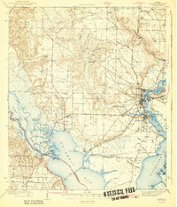
1943 Map of Milton
USGS Topo · Published 1943About this map
The Milton and Bagdad riverfronts dominate this 1940s-era survey, where the Louisville and Nashville railroad crosses the Blackwater River and Escambia Bay. The landscape is a complex network of waterways, from the East River and Dead River in the west to the tidal inlets of Bayou Mulatto and Indian Bayou to the south. Historically significant sites for genealogists include numerous family-named landmarks like Conners Mill and several burial grounds, including the Mitchell Cem, Strickland Cem, and Aclen Cem. The presence of the County Farm and the Robinson Sch near Pace reflects the rural social infrastructure of the mid-century. Industry and commerce are centered on the bays, where landings like Fishermans Pt and Liveoak Pt meet the rail lines, illustrating the region's reliance on both timber-rich swamps and coastal transport.
Find a feature on this map
77 named features on this map. Tap any name to fly to it.
Don’t see what you’re looking for? This feature index may not catch every label — zoom into the map to look around manually.
Map Details
Editions of this 1943 Milton Map
2 editions found

Other maps of this area

1920 · Milton
USGS Topo · 1:62,500

1921 · Holley
USGS Topo · 1:62,500

1921 · Pensacola
USGS Topo · 1:62,500

1921 · Fort Barrancas
USGS Topo · 1:62,500

1921 · Muscogee
USGS Topo · 1:62,500

1934 · Harold
USGS Topo · 1:62,500

1936 · Holley
USGS Topo · 1:48,000

1937 · Harold
USGS Topo · 1:62,500

1938 · Holley
USGS Topo · 1:62,500

1938 · Harold
USGS Topo · 1:62,500