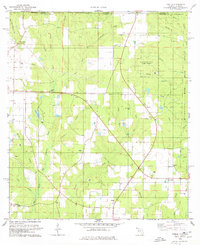
1978 Map of Fidelis
USGS Topo · Published 1978About this map
Big Coldwater Creek and its branching tributaries define the geography along the border of Florida and Alabama in the late 1970s. The landscape is a mix of small agricultural clearings and protected timberlands, most notably the Escambia National Experimental Forest and portions of the Blackwater River State Forest. Small rural communities like Fidelis and Mt Carmel serve as local anchors, with life centered around numerous country churches such as Golden Memorial Ch and Fidelis Ch. The area shows a transition from traditional farming to industrial resource extraction, evidenced by scattered Claypit locations and an Oil Well near the Alabama line. The presence of the Old Fidelis Cem and the Whitfield Ch suggests deep-rooted family ties in this Panhandle region, where the creek systems like Juniper Creek and Cobb Creek provided the primary structure for settlement long before modern roads.
Find a feature on this map
43 named features on this map. Tap any name to fly to it.
Don’t see what you’re looking for? This feature index may not catch every label — zoom into the map to look around manually.
Map Details
Editions of this 1978 Fidelis Map
2 editions found
Other maps of this area

1943 · Jay
USGS Topo · 1:62,500

1948 · Munson
USGS Topo · 1:62,500

1950 · Munson
USGS Topo · 1:62,500

1953 · Andalusia
USGS Topo · 1:250,000

1957 · Andalusia
USGS Topo · 1:250,000

1957 · Pensacola
USGS Topo · 1:250,000

1959 · Pensacola
USGS Topo · 1:250,000

1959 · Brewton South
USGS Topo · 1:24,000

1960 · Pensacola
USGS Topo · 1:250,000

1960 · Brewton South
USGS Topo · 1:24,000