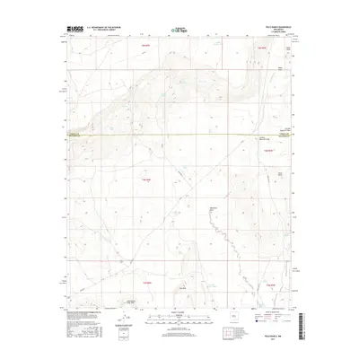
2017 Map of Field Ranch
USGS Topo · Published 2017About this map
Field Ranch lies at the heart of this high-desert landscape in New Mexico, situated along the boundary where Cibola Co and Socorro Co meet. This terrain is defined by a series of prominent mesas and deep drainage draws, such as Gag Mesa and the expansive Chicken Mountain Draw. Water management is the defining human footprint here, visible through a network of springs and man-made tanks including Friday Spring, School Section Tank, and the curiously named Coal Oil Johnnie Tank. These features suggest a history of cattle ranching and resource conservation in a land where water is a vital currency. Transportation across the high ground is facilitated by primitive routes like Bia RD 55 and Forest RD 123, which navigate the elevation changes near Cerro Pelon and Cottonwood Draw Mesa.
Find a feature on this map
33 named features on this map. Tap any name to fly to it.
Don’t see what you’re looking for? This feature index may not catch every label — zoom into the map to look around manually.
Map Details
Editions of this 2017 Field Ranch Map
This is the sole edition of this map. No revisions or reprints were ever made.
Other maps of this area

1917 · Cerro Verde
USGS Topo · 1:125,000

1917 · Broom Mountain
USGS Topo · 1:125,000

1954 · Socorro
USGS Topo · 1:250,000

1958 · Socorro
USGS Topo · 1:250,000

1962 · Socorro
USGS Topo · 1:250,000

1964 · La Jara Peak
USGS Topo · 1:24,000

1964 · Table Mountain
USGS Topo · 1:24,000

1964 · Field Ranch
USGS Topo · 1:24,000
1964 · Cerro Del Oro
USGS Topo · 1:24,000
1964 · Chicken Mountain
USGS Topo · 1:24,000