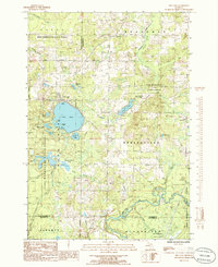
1985 Map of Fife Lake
USGS Topo · Published 1986About this map
The waters of Fife Lake dominate the western portion of this mid-1980s survey, marking a primary hub of settlement on the boundary of Grand Traverse and Kalkaska Counties. This landscape is defined by the dense woodlands of the Pere Marquette State Forest, which covers much of the terrain between the small community of Houseman and the winding course of the Manistee River to the south. The map illustrates a complex network of glacial hydrology, featuring numerous kettle lakes like Long Lake and Bloom Lake, alongside drainage systems such as Inlet Creek and Bourne Creek.
Find a feature on this map
33 named features on this map. Tap any name to fly to it.
Don’t see what you’re looking for? This feature index may not catch every label — zoom into the map to look around manually.
Map Details
Editions of this 1985 Fife Lake Map
This is the sole edition of this map. No revisions or reprints were ever made.
Other maps of this area

1954 · Traverse City
USGS Topo · 1:250,000

1956 · Kalkaska
USGS Topo · 1:62,500

1956 · Fife Lake
USGS Topo · 1:62,500

1956 · Cadillac North
USGS Topo · 1:62,500

1956 · Lake City
USGS Topo · 1:62,500

1958 · Traverse City
USGS Topo · 1:250,000

1983 · Cadillac
USGS Topo · 1:100,000

1983 · Manton
USGS Topo · 1:25,000

1983 · Traverse City
USGS Topo · 1:100,000
1983 · Morey
USGS Topo · 1:25,000
Featured Places
- Fife Lake Township, MI
- Union Township, MI
- Fife Lake, Fife Lake Township
- Bloomfield Township, MI
- Liberty Township, MI