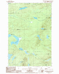
1986 Map of Fifth Musquacook Lake
USGS Topo · Published 1987About this map
Fifth Musquacook Lake and the surrounding backcountry of Northern Maine define this landscape on the border of Aroostook and Piscataquis counties. The 1980s terrain is characterized by a dense network of water bodies, including Clear Lake, Upper Hudson Pond, and the chain of Elbow Ponds. The map reveals a land managed for timber and recreation, marked by several Shale Pits and a Gravel Pit alongside a network of Private roads and designated Campsites. High points like Hudson Mountain and the Rocky Mountains rise above the drainage basins of Big Hudson Brook and Mule Brook. This survey captures the remote wilderness character of the T 11 R 11 and T 10 R 10 WELS townships during a period of active land management, providing a clear record of the watershed and logging infrastructure before modern digital mapping.
Find a feature on this map
35 named features on this map. Tap any name to fly to it.
Don’t see what you’re looking for? This feature index may not catch every label — zoom into the map to look around manually.
Map Details
Editions of this 1986 Fifth Musquacook Lake Map
This is the sole edition of this map. No revisions or reprints were ever made.
Other maps of this area

1931 · Mooseleuk Lake
USGS Topo · 1:48,000

1932 · Musquacook Lakes
USGS Topo · 1:48,000

1935 · Musquacook Lakes
USGS Topo · 1:62,500

1935 · Mooseleuk Lake
USGS Topo · 1:62,500

1954 · Spider Lake
USGS Topo · 1:62,500

1954 · Millinocket Lake
USGS Topo · 1:62,500

1954 · Presque Isle
USGS Topo · 1:250,000

1958 · Presque Isle
USGS Topo · 1:250,000

1960 · Presque Isle
USGS Topo · 1:250,000

1961 · Spider Lake
USGS Topo · 1:62,500