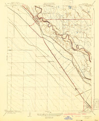
1941 Map of Firebaugh
USGS Topo · Published 1941About this map
The San Joaquin River defines the central spine of this Central Valley landscape, serving as the Boundary Line between Fresno and Madera counties during the early 1940s. The region is characterized by an intensive irrigation and transport network, dominated by the San Joaquin and Kings River Canal and the Southern Pacific railroad line running parallel to the water. Agricultural and industrial development is evident at the Standard Oil Pump Station and various agricultural outposts like the Helm Ranch and East Side Farm. The settlement pattern follows the rail corridor, connecting Firebaugh in the northwest to Mendota in the southeast, with smaller stops such as Arbios and Cromir situated along the tracks. This era shows the San Joaquin Valley’s transition into a highly engineered hydraulic landscape, where the Kings River Canal and Lone Willow Slough supported large-scale ranching and farming operations.
Find a feature on this map
16 named features on this map. Tap any name to fly to it.
Don’t see what you’re looking for? This feature index may not catch every label — zoom into the map to look around manually.
Map Details
Editions of this 1941 Firebaugh Map
This is the sole edition of this map. No revisions or reprints were ever made.
Other maps of this area

1913 · Panoche
USGS Topo · 1:125,000

1921 · Mendota
USGS Topo · 1:31,680

1922 · Oxalis
USGS Topo · 1:31,680

1922 · Tufts Ranch
USGS Topo · 1:31,680

1922 · Pozo Farm
USGS Topo · 1:31,680

1922 · Kentucky Well
USGS Topo · 1:31,680

1922 · Chaney Ranch
USGS Topo · 1:31,680

1923 · Wisdom Well
USGS Topo · 1:31,680

1923 · Firebaugh
USGS Topo · 1:31,680

1924 · Tranquillity
USGS Topo · 1:31,680