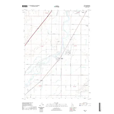
2020 Map of Firth
USGS Topo · Published 2020About this map
The Snake River Valley defines this agricultural corridor in Bingham County, where a sophisticated network of irrigation channels supports the local economy. Established settlements like Firth, Shelley, and Basalt are clustered along the eastern side of the Snake River, while smaller nodes like Goshen Junction and Kimball mark important crossroads in the rural landscape. The map reveals the intricate engineering of the high desert, with the Great Western Canal, Aberdeen Springfield Canal, and Reservation Canal diverting water across the plains. These water systems, alongside numerous laterals like the Steel Lateral and Monson Lateral, illustrate the intensive land management required for cultivation in this part of Idaho. Genealogists can find several established burial grounds serving these communities, including Riverview Cem, Basalt Cem, and Hillcrest Cem. To the southeast, the terrain rises toward Presto Bench near the confluence where the Blackfoot River enters the valley.
Find a feature on this map
61 named features on this map. Tap any name to fly to it.
Don’t see what you’re looking for? This feature index may not catch every label — zoom into the map to look around manually.
Map Details
Editions of this 2020 Firth Map
This is the sole edition of this map. No revisions or reprints were ever made.
Other maps of this area

1940 · Blackfoot
USGS Topo · 1:62,500

1943 · Blackfoot
USGS Topo · 1:62,500

1948 · Woodville
USGS Topo · 1:24,000

1948 · Idaho Falls South
USGS Topo · 1:24,000

1950 · Woodville
USGS Topo · 1:24,000

1950 · Idaho Falls South
USGS Topo · 1:24,000

1950 · Goshen
USGS Topo · 1:24,000

1951 · Higham Peak
USGS Topo · 1:24,000

1952 · Goshen
USGS Topo · 1:24,000

1955 · Lincoln Creek
USGS Topo · 1:24,000