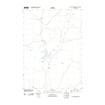
2010 Map of Fish Creek Reservoir
USGS Topo · Published 2010About this map
Fish Creek Reservoir dominates this high-altitude landscape, serving as a vital catchment for the drainage network that feeds into the Fish Creek Dam. The hydrology is defined by the convergence of several major tributaries, including West Fork Fish Creek, East Fork Fish Creek, and Fish Creek, which carve deep canyons through the mountainous terrain. Named topographic landmarks such as Stinson Hill, Pine Mountain, and Brassfield Canyon reflect a history of local land naming probably tied to early ranching or homesteading families. A network of unpaved roads, including W Fork Fish Creek Rd and Fish Creek Reservoir Rd, provides access to this isolated area, including the Fish Creek Reservoir Access Area. The map reveals a landscape managed for water storage and seasonal access, punctuated by remote water sources like Timber Butte Spring.
Find a feature on this map
22 named features on this map. Tap any name to fly to it.
Don’t see what you’re looking for? This feature index may not catch every label — zoom into the map to look around manually.
Map Details
Editions of this 2010 Fish Creek Reservoir Map
This is the sole edition of this map. No revisions or reprints were ever made.
Other maps of this area

1935 · MacKay
USGS Topo · 1:96,000

1955 · Idaho Falls
USGS Topo · 1:250,000

1958 · Idaho Falls
USGS Topo · 1:250,000

1960 · Muldoon Canyon
USGS Topo · 1:62,500

1960 · Grouse
USGS Topo · 1:62,500

1972 · Little Park
USGS Topo · 1:24,000

1972 · Blizzard Mtn South
USGS Topo · 1:24,000

1978 · Craters Of The Moon
USGS Topo · 1:100,000
1979 · Paddelford Flat
USGS Topo · 1:24,000
1979 · Lake Hills
USGS Topo · 1:24,000