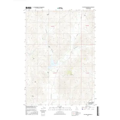
2017 Map of Fish Creek Reservoir
USGS Topo · Published 2017About this map
Fish Cr Reservoir serves as a central hub for the drainage networks of Blaine County, where several mountain streams converge at the edge of volcanic highlands. The landscape is defined by its deep drainage systems, including Brassfield Canyon, Stinson Canyon, and Bown Canyon, which guide water into the reservoir from the surrounding heights. These natural features are accessed by a network of unimproved roads like Fish Creek Rd and W Fork Fish Creek Rd, which follow the serpentine paths of the valley floors.
Find a feature on this map
25 named features on this map. Tap any name to fly to it.
Don’t see what you’re looking for? This feature index may not catch every label — zoom into the map to look around manually.
Map Details
Editions of this 2017 Fish Creek Reservoir Map
This is the sole edition of this map. No revisions or reprints were ever made.
Other maps of this area

1935 · MacKay
USGS Topo · 1:96,000

1955 · Idaho Falls
USGS Topo · 1:250,000

1958 · Idaho Falls
USGS Topo · 1:250,000

1960 · Muldoon Canyon
USGS Topo · 1:62,500

1960 · Grouse
USGS Topo · 1:62,500

1972 · Little Park
USGS Topo · 1:24,000

1972 · Blizzard Mtn South
USGS Topo · 1:24,000

1978 · Craters Of The Moon
USGS Topo · 1:100,000
1979 · Paddelford Flat
USGS Topo · 1:24,000
1979 · Lake Hills
USGS Topo · 1:24,000