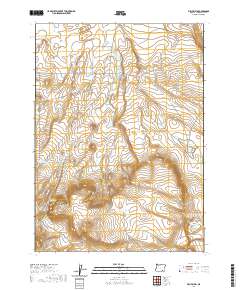
2020 Map of Fish Fin Rim
USGS Topo · Published 2020About this map
The Old Military Rd traces a historic path across this high desert landscape in Harney County, providing a glimpse into early transit routes through the eastern Oregon interior. The terrain is defined by dramatic escarpments, most notably the Fish Fin Rim and Big Fish Fin, which overlook the vast expanse of the Catlow Valley to the north. These geological features dominate the southwestern portion of the map, while the surrounding area is punctuated by essential water sources for cattle and wildlife, such as East Gulch Waterhole, Rimrock Waterhole, and Bench Top Waterhole.
Find a feature on this map
17 named features on this map. Tap any name to fly to it.
Don’t see what you’re looking for? This feature index may not catch every label — zoom into the map to look around manually.
Map Details
Editions of this 2020 Fish Fin Rim Map
This is the sole edition of this map. No revisions or reprints were ever made.
Other maps of this area

1955 · Adel
USGS Topo · 1:250,000

1957 · Adel
USGS Topo · 1:250,000

1958 · Adel
USGS Topo · 1:250,000

1962 · Adel
USGS Topo · 1:250,000

1971 · Fish Fin Rim
USGS Topo · 1:24,000

1971 · Beatys Butte
USGS Topo · 1:24,000

1971 · Surveyors Lake
USGS Topo · 1:24,000

1971 · Blitzen
USGS Topo · 1:24,000

1971 · Coyote Gap SE
USGS Topo · 1:24,000

1971 · Mahogany Butte
USGS Topo · 1:24,000