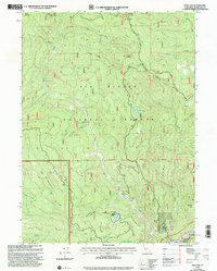
1997 Map of Fish Lake
USGS Topo · Published 2001About this map
Six Rivers National Forest blankets this corner of Humboldt County, where high peaks like Onion Mountain and Bee Mountain overlook a complex system of drainage basins and isolated lakes. This late-twentieth-century revision illustrates a landscape defined by its hydrology and elevations, from the Klamath River in the southeast corner to the high Twin Lakes and Mosquito Lake in the north. The presence of the Wright Place (Site) near Bluff Creek provides a rare point of named habitation in an otherwise dense wilderness terrain. The map meticulously tracks the winding course of Big Foot Creek and Fish Creek, alongside the rugged ridge-running path of Cedar Camp Road. This era of the forest is captured through its network of springs and glades, including Mud Spring and the Red Cap Glade, showing the intricate details of California's coastal range drainage.
Find a feature on this map
36 named features on this map. Tap any name to fly to it.
Don’t see what you’re looking for? This feature index may not catch every label — zoom into the map to look around manually.
Map Details
Editions of this 1997 Fish Lake Map
This is the sole edition of this map. No revisions or reprints were ever made.
Other maps of this area

1925 · Hoopa
USGS Topo · 1:125,000

1945 · Coyote Peak
USGS Topo · 1:62,500

1945 · Tectah Creek
USGS Topo · 1:62,500

1948 · Weed
USGS Topo · 1:250,000

1950 · Weed
USGS Topo · 1:250,000

1952 · Coyote Peak
USGS Topo · 1:62,500

1952 · Hoopa
USGS Topo · 1:62,500

1952 · Orleans
USGS Topo · 1:62,500

1952 · Tectah Creek
USGS Topo · 1:62,500

1958 · Weed
USGS Topo · 1:250,000