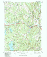
1983 Map of Fitchville
USGS Topo · Published 1984About this map
Fitchville and the surrounding township of Bozrah are defined by the winding course of the Yantic River as it passes through the center of this New London County landscape. During the early 1980s, the area maintained a balance between rural hill country and modern infrastructure, as evidenced by the proximity of the Central Vermont railroad line to several major interchanges. Small crossroads like Bozrah Street and Smith Corner anchor the community, while the presence of numerous family-named burial grounds including Parker Cem and Gardner Bulkeley Cem provides significant clues for genealogical research. The map also highlights the recreational importance of the region's large water bodies, such as Gardner Lake and Red Cedar Lake, which are bordered by state parklands like Minnie Island State Park. Local education and civil services are represented by landmarks such as Fields Mem Sch and the Radio Tower (WEDN).
Find a feature on this map
87 named features on this map. Tap any name to fly to it.
Don’t see what you’re looking for? This feature index may not catch every label — zoom into the map to look around manually.
Map Details
Editions of this 1983 Fitchville Map
This is the sole edition of this map. No revisions or reprints were ever made.
Other maps of this area

1892 · New London
USGS Topo · 1:62,500

1892 · Norwich
USGS Topo · 1:62,500

1892 · Gilead
USGS Topo · 1:62,500

1893 · New London
USGS Topo · 1:62,500

1893 · Saybrook
USGS Topo · 1:62,500

1921 · New London
USGS Topo · 1:62,500

1935 · Montville
USGS Topo · 1:24,000

1939 · Montville
USGS Topo · 1:31,680
1941 · Uncasville
USGS Topo · 1:31,680

1943 · Fitchville
USGS Topo · 1:31,680