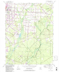
1994 Map of Five Points
USGS Topo · Published 1998About this map
Vineland and Millville anchor this southern New Jersey landscape, where established institutional grounds and residential grids meet the dense pine and cedar wetlands of the Outer Coastal Plain. The northern reaches are characterized by the sprawling Vineland State School and the Vineland Training School, alongside the Manantico Colony. The area's agricultural and rural heritage is visible in the smaller settlements of East Vineland, New Italy, and Five Points, where local landmarks like Our Lady of Pompeii Ch and St Marys Ch served these communities.
Find a feature on this map
77 named features on this map. Tap any name to fly to it.
Don’t see what you’re looking for? This feature index may not catch every label — zoom into the map to look around manually.
Map Details
Editions of this 1994 Five Points Map
This is the sole edition of this map. No revisions or reprints were ever made.
Other maps of this area

1890 · Hammonton
USGS Topo · 1:62,500

1890 · Tuckahoe
USGS Topo · 1:62,500

1890 · Bridgeton
USGS Topo · 1:62,500

1890 · Glassboro
USGS Topo · 1:62,500

1893 · Tuckahoe
USGS Topo · 1:62,500

1894 · Hammonton
USGS Topo · 1:62,500

1894 · Bridgeton
USGS Topo · 1:62,500

1898 · Glassboro
USGS Topo · 1:62,500

1898 · Hammonton
USGS Topo · 1:62,500

1899 · Vineland
USGS Topo · 1:125,000