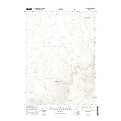
2014 Map of Five Points
USGS Topo · Published 2014About this map
Oglala National Grassland dominates the high plains landscape of Sioux County, where a complex network of ephemeral drainage and livestock reservoirs supports ranching operations. The terrain is defined by the transition from the relatively level northern plains near Jim Cr and W Jim Cr toward the significant elevation changes found at Beans Canyon in the south. Named local features such as Staudenmaier Reservoir, Wickersham Reservoir, and Eberspecher Reservoir suggest a lineage of family land management in this arid environment. Transportation through the area relies on a grid of rural routes including Orella Rd and Hat Creek Rd, converging near the site of Five Points. The map captures the specialized water management infrastructure necessary for this region, with multiple named reservoirs like Coffee Reservoir Number 1 and Serres Reservoir Number 2 dotting the drainages of Licket Cr and Boggy Cr.
Find a feature on this map
28 named features on this map. Tap any name to fly to it.
Don’t see what you’re looking for? This feature index may not catch every label — zoom into the map to look around manually.
Map Details
Editions of this 2014 Five Points Map
This is the sole edition of this map. No revisions or reprints were ever made.
Other maps of this area

1955 · Alliance
USGS Topo · 1:250,000

1957 · Alliance
USGS Topo · 1:250,000

1958 · Alliance
USGS Topo · 1:250,000

1979 · Harrison East
USGS Topo · 1:24,000

1980 · Montrose
USGS Topo · 1:24,000

1980 · Smiley Canyon
USGS Topo · 1:24,000

1980 · Five Points
USGS Topo · 1:24,000

1980 · Andrews
USGS Topo · 1:24,000
1980 · Orella
USGS Topo · 1:24,000
1980 · Roundtop
USGS Topo · 1:24,000