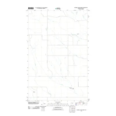
2011 Map of Fivemile Coulee West
USGS Topo · Published 2011About this map
The Kevin-Sunburst Oil Fld defines the industrial footprint of this high plains landscape in Toole County, where a rigid grid of section-line roads overlies the natural drainages of the Missouri River watershed. While much of the terrain is shaped by seasonal watercourses like Minnesota Coulee and Elmer Coulee, the human impact on the environment is visible through the infrastructure of The Reservoir Dam and Tomsheck Dam. These water management features, alongside named thoroughfares such as Pederson Rd and Wallewein Rd, suggest a rural economy reliant on both livestock and energy extraction. The map captures a moment in the early 21st century when traditional ranching roads intersected with the technical requirements of the northern Montana oil fields.
Find a feature on this map
13 named features on this map. Tap any name to fly to it.
Don’t see what you’re looking for? This feature index may not catch every label — zoom into the map to look around manually.
Map Details
Editions of this 2011 Fivemile Coulee West Map
This is the sole edition of this map. No revisions or reprints were ever made.
Other maps of this area

1939 · Sunburst
USGS Topo · 1:62,500

1943 · Antelope Coulee
USGS Topo · 1:62,500

1943 · Shelby
USGS Topo · 1:62,500

1945 · West Butte
USGS Topo · 1:62,500

1954 · Shelby
USGS Topo · 1:250,000

1958 · Shelby
USGS Topo · 1:250,000

1984 · Sweet Grass Hills
USGS Topo · 1:100,000
1986 · Ferdig
USGS Topo · 1:24,000
1986 · Antelope Coulee NW
USGS Topo · 1:24,000
1986 · Johannson Coulee
USGS Topo · 1:24,000