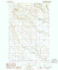
1986 Map of Fivemile Coulee West
USGS Topo · Published 1986About this map
The Principal Meridian bisects this high plains landscape of Toole County during the mid-1980s, revealing an area defined by its energy infrastructure and natural drainage patterns. The map documents an extensive Oil Field in the southwestern quadrant, supported by numerous Oil Well and Gas Well sites. This industrial development is overlaid upon a rugged system of coulees, including Twomile Coulee, Fivemile Coulee, and Black Coulee, which carve through the terrain toward Willow Cr in the northeast. The presence of multiple Pipelines and an Aqueduct underscores the complex management of resources in this arid environment, providing a technical look at the intersection of petroleum extraction and topographic features during this era of Montana’s history.
Find a feature on this map
12 named features on this map. Tap any name to fly to it.
Don’t see what you’re looking for? This feature index may not catch every label — zoom into the map to look around manually.
Map Details
Editions of this 1986 Fivemile Coulee West Map
This is the sole edition of this map. No revisions or reprints were ever made.
Other maps of this area

1939 · Sunburst
USGS Topo · 1:62,500

1943 · Antelope Coulee
USGS Topo · 1:62,500

1943 · Shelby
USGS Topo · 1:62,500

1945 · West Butte
USGS Topo · 1:62,500

1954 · Shelby
USGS Topo · 1:250,000

1958 · Shelby
USGS Topo · 1:250,000

1984 · Sweet Grass Hills
USGS Topo · 1:100,000
1986 · Ferdig
USGS Topo · 1:24,000
1986 · Antelope Coulee NW
USGS Topo · 1:24,000
1986 · Johannson Coulee
USGS Topo · 1:24,000