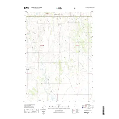
2018 Map of Fivemile Gulch
USGS Topo · Published 2018About this map
Sawtooth National Forest straddles the border between Nevada and Idaho, defining the northern reaches of this high-desert landscape in Elko and Cassia counties. The terrain is a network of drainages and seasonal water sources, including the prominent Fivemile Gulch and the winding course of Goose Creek. High points like Sugar Loaf Peak overlook a system of springs such as Buck Springs, Whitley Davis Spring, and Fivemile Springs, which have historically been vital for livestock and local wildlife. Transportation through this remote ranching country is dictated by the few improved paths, notably Goose Creek Road and Wine Cup Ranch Road. The map provides a detailed view of the township and range survey system, revealing how water rights and land management are organized around these isolated creeks like Bottom Creek and Trout Creek.
Find a feature on this map
25 named features on this map. Tap any name to fly to it.
Don’t see what you’re looking for? This feature index may not catch every label — zoom into the map to look around manually.
Map Details
Editions of this 2018 Fivemile Gulch Map
This is the sole edition of this map. No revisions or reprints were ever made.
Other maps of this area

1955 · Twin Falls
USGS Topo · 1:250,000

1955 · Wells
USGS Topo · 1:250,000

1958 · Wells
USGS Topo · 1:250,000

1958 · Twin Falls
USGS Topo · 1:250,000

1961 · Wells
USGS Topo · 1:250,000

1961 · Gollaher Mountain
USGS Topo · 1:62,500

1961 · Goose Creek
USGS Topo · 1:62,500

1977 · Timber Butte
USGS Topo · 1:24,000

1977 · Mahogany Butte
USGS Topo · 1:24,000
1977 · Ibex Peak
USGS Topo · 1:24,000