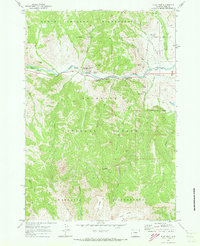
1970 Map of Flag Peak
USGS Topo · Published 1973About this map
The North Fork Shoshone River carves a central valley through this 1970s wilderness survey, creating a vital corridor for both travel and seasonal habitation in Park County. Along the banks of the river and its tributaries like Horse Creek, the map records a series of recreational and administrative outposts including the Wapiti Ranger Sta, Big Game Campground, and the Horse Creek Picnic Area. The terrain is punctuated by distinctive geological formations with evocative names such as Anvil Rock, Goose Rock, and the cathedral-like spires of Holy City.
Find a feature on this map
38 named features on this map. Tap any name to fly to it.
Don’t see what you’re looking for? This feature index may not catch every label — zoom into the map to look around manually.
Map Details
Editions of this 1970 Flag Peak Map
This is the sole edition of this map. No revisions or reprints were ever made.
Other maps of this area

1893 · Ishawooa
USGS Topo · 1:125,000

1895 · Ishawooa
USGS Topo · 1:125,000

1896 · Crandall Creek
USGS Topo · 1:125,000

1899 · Crandall
USGS Topo · 1:125,000

1899 · Ishawooa
USGS Topo · 1:125,000

1949 · Pat O'Hara Mountain
USGS Topo · 1:62,500

1955 · Cody
USGS Topo · 1:250,000

1956 · Dead Indian Peak
USGS Topo · 1:62,500

1957 · Wapiti
USGS Topo · 1:62,500

1958 · Cody
USGS Topo · 1:250,000