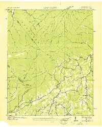
1936 Map of Flag Pond
USGS Topo · Published 1936About this map
The Tennessee-North Carolina border cuts across this 1936 survey, where the Appalachian Trail follows the high ridgeline of Cold Spring Mountain and Divide Mountain. Settlement is concentrated in the deep valleys of the Unicoi County interior, particularly around the hub of Flag Pond. The landscape is a network of small family-centered locales and service points, including the Clearbranch PO, the Faith Tabernacle, and numerous small schools such as Sweetwater School and Ennis School.
Find a feature on this map
102 named features on this map. Tap any name to fly to it.
Don’t see what you’re looking for? This feature index may not catch every label — zoom into the map to look around manually.
Map Details
Editions of this 1936 Flag Pond Map
This is the sole edition of this map. No revisions or reprints were ever made.
Other maps of this area

1891 · Roan Mountain
USGS Topo · 1:125,000

1892 · Greeneville
USGS Topo · 1:125,000

1894 · Asheville
USGS Topo · 1:125,000

1894 · Roan Mountain
USGS Topo · 1:125,000

1896 · Greeneville
USGS Topo · 1:125,000

1900 · Mount Mitchell
USGS Topo · 1:125,000

1901 · Asheville
USGS Topo · 1:125,000

1902 · Mount Mitchell
USGS Topo · 1:125,000

1904 · Roan Mountain
USGS Topo · 1:125,000

1904 · Greeneville
USGS Topo · 1:125,000