
1960 Map of Flagstaff
USGS Topo · Published 1960About this map
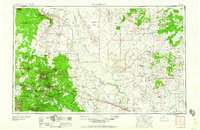
The Atchison Topeka and Santa Fe railroad corridor anchors this mid-century landscape, tracing a path through the high plateau country past Flagstaff and the industrial activity of the Navajo Ordnance Depot. To the east, the route passes the massive depression of Meteor Crater before reaching Winslow. The map captures a complex cultural geography, illustrating the extensive borders of the Navajo Indian Reservation and Hopi Indian Reservation, where ancient settlements like Old Oraibi and Shungopovi sit atop the mesas. The transition from the timbered heights of the Coconino National Forest to the arid expanses of the Painted Desert is clearly marked by the winding course of the Little Colorado River. Remote trading posts, such as the Gray Mountain Trading Post and Sunrise Trading Post, appear as vital outposts along the early roads connecting these isolated mesa communities and desert landmarks.
Find a feature on this map
116 named features on this map. Tap any name to fly to it.
Don’t see what you’re looking for? This feature index may not catch every label — zoom into the map to look around manually.
Map Details
Editions of this 1960 Flagstaff Map
2 editions found
Other maps of this area

1883 · Marsh Pass
USGS Topo · 1:250,000

1883 · Tusayan
USGS Topo · 1:250,000

1886 · St Johns
USGS Topo · 1:250,000

1886 · Tusayan
USGS Topo · 1:250,000

1886 · Fort Defiance
USGS Topo · 1:250,000

1886 · San Francisco Mtns
USGS Topo · 1:250,000

1886 · Chino
USGS Topo · 1:250,000

1886 · Echo Cliffs
USGS Topo · 1:250,000

1886 · Holbrook
USGS Topo · 1:250,000

1886 · Kaibab
USGS Topo · 1:250,000