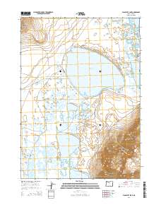
2014 Map of Flagstaff Lake
USGS Topo · Published 2014About this map
Flagstaff Lake and its surrounding wetlands dominate this 2014 survey of Lake County, where high desert plateaus meet the expansive basin of the Warner Valley. The landscape is defined by its interior drainage system, featuring a chain of ephemeral and permanent water bodies including Mugwump Lake, Swamp Lake, and Upper Campbell Lake. These waters are set against the striking verticality of Hart Mtn and the Rabbit Hills, illustrating the Great Basin's characteristic basin-and-range topography.
Find a feature on this map
22 named features on this map. Tap any name to fly to it.
Don’t see what you’re looking for? This feature index may not catch every label — zoom into the map to look around manually.
Map Details
Editions of this 2014 Flagstaff Lake Map
This is the sole edition of this map. No revisions or reprints were ever made.
Other maps of this area

1955 · Adel
USGS Topo · 1:250,000

1957 · Adel
USGS Topo · 1:250,000

1958 · Adel
USGS Topo · 1:250,000

1962 · Adel
USGS Topo · 1:250,000

1966 · Rabbit Hills NE
USGS Topo · 1:24,000

1966 · Rabbit Hills NW
USGS Topo · 1:24,000

1967 · Flagstaff Lake
USGS Topo · 1:24,000

1967 · Plush
USGS Topo · 1:24,000

1967 · Rabbit Hills SW
USGS Topo · 1:24,000

1967 · Campbell Lake
USGS Topo · 1:24,000